Proposed Concepts
Williamson County
View map to learn about current improvements to I-35 in Williamson County. Studies to identify short and mid-term improvement strategies for this portion of I-35 are underway.
I-35 Williamson County Feasibility Study - SH 130 to south of RM 1431
The I-35 Williamson County Feasibility Study was launched in November 2013. Over the course of the study, a range of concepts will be developed and analyzed that will take into account the needs of drivers, transit riders, bicyclists and pedestrians as well as surrounding businesses, neighborhoods and the environment.
The study is anticipated to be complete by mid-2015. Concepts identified through the feasibility study will be incorporated into the I-35 Capital Area Implementation Plan. The Plan will guide the development of projects along the I-35 corridor throughout Williamson, Travis and Hays counties.
Fact sheet describing the Williamson County Feasibility Study
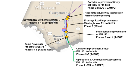
RM 1431 to SH 45N
Specific elements of the proposed operational improvements to I-35 in the vicinity of Round Rock include:
- Non-continuous auxiliary lanes constructed in both the northbound and southbound directions to provide space for vehicles to change speed and merge with traffic when entering or exiting the Interstate.
- The existing outdated bridge at FM 3406 would be reconstructed.The bridge would be wider to incorporate additional turn lanes. In addition, U-turn bridges would be constructed at FM 3406 to allow U-Turn movements without going through the traffic signal.
- Proposed improvements at US 79 would include the construction of additional turn lanes.The westbound to southbound left turn is proposed to be three lanes.
- The existing outdated bridge at Round Rock Avenue would be reconstructed.
- Ramps would be reconfigured to make exits and entrances onto I-35 more efficient and improve operations of the mainlanes, frontage roads, and intersections.
- Proposed improvements would tie to proposed improvements at RM 1431 that are currently under design.
Fact sheet describing proposed improvements along I-35 from RM 1431 to SH 45 N
Click below for preliminary engineering plans
-
Roll Plot (1/4) – engineering details on aerial photo
Roll Plot (2/4) – engineering details on aerial photo
Roll Plot (3/4) – engineering details on aerial photo
Roll Plot (4/4) – engineering details on aerial photo
Intersection at Old Settler's Blvd – engineering details on aerial photo
Intersection at US 79 – engineering details on aerial photo
Intersection at Round Rock Ave – engineering details on aerial photo
I-35 Typical Section – engineering details
Braided ramps at McNeil – engineering details on aerial photo
RM 1431 Proposed Improvements - Diverging Diamond Intersection
TxDOT is considering replacing the traditional intersection at RM 1431 (University Blvd.) and I-35 in Round Rock with a Diverging Diamond Intersection (DDI).
A DDI is a new intersection design that can improve traffic flow and reduce congestion. It changes the normal four-phase signal operations to a more-efficient two-phase operation, which allows more flexibility addressing current and future traffic volumes.
Fact sheet describing proposed DDI
Ramp Reversals FM 3406 to US 79
Reconstruction of entrance and exit ramps on I-35 between FM 3406 and US 79 is planned in Round Rock. Proposed improvements include:
- Reconstruction of exit ramps
- Construction of auxiliary lanes between exit and entrance ramps on frontage roads
- Move exit ramps further back from intersections to allow more room for traffic
- No additional right-of-way would be required and no relocations or displacements are anticipated
Need help understanding some of the terms and solutions identified on this page?
Visit our Frequently Asked Questions section for a glossary of terms.